El Camino del Diablo – Dec 2020

Dates: December 8-9, 2020

Vehicle: 2020 Jeep Wrangler JK, Rubicon, stock

Permit: iSportsman via https://luke.isportsman.net

Resource: A Visitor’s Guide to El Camino del Diablo (2016)

I primarily used this resource as it could be downloaded and used offline. It was a bit convoluted to follow, but once you figure out the paging it was invaluable. I found this as a .pdf at Sierraclub.org

Overnight accomodations

Ajo – Sonoran Desert Inn & Conference Center, highly recommended

http://www.sonorancc.com

Yuma – national motel chain 

Route:

Day 1 – Ajo to Tule Well to Wellton

Day 2 – Yuma to Tinajas Altas to Tule Well to Tacna

Day 1

  The night before we arrived in Ajo and checked into the Sonoran Desert Inn & Conference Center, a delightful place to stay. This is operated as a non-profit, in a refurbished elementary school. The rooms are very comfortable and spacious. After a comfortable night we drove out of Ajo east to Darby Well Road to start the first part of our trip, starting a bit after 9 AM. 

   After driving through the Bureau of Land Management area, which allows dispersed camping, we entered the Organ Pipe Cactus National Monument. We did see a few of the iconic Organ Pipe cactus, mainly along slopes to the east. We bypassed Bates Well, we had spent time there last Spring. Well worth a stop and time spent exploring the structures. 

   The road so far was well-graded and suitable for any 2 WD, as it remains up to the Cabeza Prieta National Wildlife Refuge (NWR) entrance. At the entrance sign is a sign-in stand which has permits to record your trip details, this is in addition to the permit you must secure online before starting the trip. That permit is a print out which is to remain on your dashboard and provides a permit number used for the permits (one per person) at the NWR entrance. The permit at the East entrance was more detailed than the one we completed the next day at the West entrance.

  Once on the refuge the road became narrower, but still 2 WD. It wasn’t until we entered Las Playas, at mile 47 (from Darby Well Rd & AZ 85) that sand became deeper and 4 WD recommended. After any rain this section could be impassable, check with NWR staff before starting the route. A few days before they confirmed via e-mail the route was in good shape and passable in this area. The guide mentions the use of metal landing mats, we saw these off to the side of the road, never in the roadway. Shortly we entered the Pinacate Lava Flow, rough rocks, but nothing difficult to traverse, just slow down. 

  Near mile 50, looking Northwest you notice a mountain range where a light section meets a dark section, the Sierra Pinta.  This is a geologic example of horst and graben, a fault line displaying one block up, one block down. The surrounding area also has some dramatic lava peaks. We stopped for lunch in a wash near mile 63.8. We had hoped to see bighorn sheep in the surrounding hills, but no luck.  

   At mile 66.8 an administrative road came in from the southeast and the road doubled in width and smoothed out. No research prepared us for this, a construction road for the Border Wall. Along with the new road came lots of large trucks and other vehicles. This continued all the way into Wellton and I-8. We stopped briefly at Tule Well to see the cabin built in 1989 by the military to commemorate the 50th anniversary of the NWR. Further along was a nice view of Tordillo Mountain.

   As we headed northwest to I-8 and left the Goldwater Military Range this sign gave the best history of El Camino del Diablo. We ended the day in Yuma, staying overnight in a motel. 

Day 2

   Starting from Yuma we went south on Foothills Blvd, entering the Western section of the Goldwater Military Range. Prior to starting I used the Visitor Guide to reverse the mileage, as the guide is written from east to west. We stayed along the pole line road, not taking the side trip to the Fortuna Mine, we’ll do that at another time. 

   After a straight shot south we turned east and began heading towards mountains. All along the southern edge of the road were signs warning us of unexploded ordnance. The best views were to the north, passing rugged hills of solid rock.

    Along this stretch we saw one stationary mobile Border Patrol truck, but no other vehicles till we reached the other side of Tinajas Altas. Wooden posts mark the way, acting as confidence markers at various intersections, as well as a few small brown signs identifying El Camino del Diablo. The only question we had was at A13, but stopping and checking the guide kept us on the best path. Along this stretch there were quite a few sandy wash crossing, more washboard than yesterday and maybe one place where high-clearance was needed. The drive approaching Tinajas Altas was interesting as you couldn’t figure out where you were headed. Once at the pass we were surprised at how wide the area was between mountains on each side. It was a nice place to take a break after about 2 hours of driving.  

   East of here we quickly reached the wide construction road which took us back to Tule Well. We stopped here for quick bite of lunch before heading north to Christmas Pass.

This route was popular over a century ago, considered to be the quickest route to reliable water along the Gila River. After driving the route I can’t imagine how they kept supplied with water along the way.  This was a beautiful section, heading through some mining claims and shapely hills. You pass remains of camp from the 1940’s. Dan Drift lived out here and fashioned the road at Christmas Pass so he could get to Wellton for supplies. The next 2 miles were where 4 WD and high clearance were necessary. We saw no one else along this section until we turned the corner at Christmas Pass and saw a group of 5 OHVs and their riders enjoying lunch at the campground. 

  From here the road was a narrow wash bed that headed north to I-8, about 37 miles. As you approached the Mohawk Dunes at mile 30 the road became wide and more solid. The views along the drive were primarily of mountains in the distance and large expanses of creosote bushes roadside. One place worth stopping was for a very large Ironwood tree, I can only imagine how beautiful it would be when blooming in the spring. 

 The sand was never a concern for driving, in fact you still felt the washboard beneath. The guide book indicated you would turn left near mile 40 to head back west before reaching the on ramp for I-8. We missed that turn and literally came up to an open gate at the shoulder of I-8. As we were heading east, back to Tucson, we carefully entered I-8 there, no signs were present to indicate no entry or exit. 

   Overall the trip was excellent, two days of mid-70 degrees and no wind made for the best weather possible to enjoy the route. As other write ups reveal there are a number of sights along the way to stop and explore. As this was our first time having a vehicle we felt comfortable driving the routes we wanted to see what was there and where we would spend more time in the future. 

   A great place to practice physical distancing during the covid pandemic. Overall we probably saw 5 Border Patrol vehicles, 2 helicopters, maybe 3 other private vehicles, the OHV group and numerous construction vehicles. Before reaching the Las Playas a Border Patrol agent chatted with us while we were out of the car exploring O’Neill’s gravesite. He warned us they were tracking 8 migrants further up the road, that is where we saw 2 helicopters close to the ground flying in tight circles. It was well north of the road and didn’t affect our route. The only surprise of the trip was the developed construction road right in the middle of El Camino del Diablo. 

   We accomplished our goal of driving the different routes and are looking forward to return trips in the future.  

Minidoka National Historic Site – Idaho

Minidoka National Historic Site
Idaho

http://www.nps.gov/miin/index.htm

Completed: June 13,2018

This stop along our route was a re-visit to this site. It was good to see that there is now a visitor center, interpretive signs, ballpark and other buildings in progress of being restored. The ranger on duty was a wealth of information, providing excellent information about this historic site. I always find it difficult to visit the sites within the National Park Service which interpret dark times in our history, but I appreciate the honesty which the information is presented. The site is small and the Junior Ranger booklet can be completed easily during a short visit.

The program is not Senior Friendly as the oldest age listed is 12, however the ranger on duty readily provided the booklet to this Senior. Of the 11 activities in the booklet, 6 are to be completed by these 6-9 years old and 8 of the activities by those 10-12 years old.


The eleven activities are;
Minidoka Word Search – 15 words related to this site.
What Would You Take? – with only five days notice and just able to bring suitcases this activity had you list what you would bring, how much could you fit in one suitcase and what you would have to leave behind. This was difficult and eye-opening.
Connect the Centers – Matching the 10 Relocation Centers with the states scattered in 7 Western states,
Minidoka Journal – writing about a day of life in the camp. I wrote about the heat and wind and a brother playing baseball.
Haiku – Bright blue skies
Thinking of grey skies
And going home soon
Fill-in-the-Blank – 7 words are given to complete sentences which provide background about relocation camps.
Finding Your Way Home – a quick maze based on when the Japanese-Americans began returning home in 1945.
Color By Number – coloring the logo for this site, the entry gate.
Ask A Ranger – I learned that most of the internees at Minidoka came from the Pacific NW.
Was It There? – deciding if typical buildings in a city were present at Minidoka; such as post office, library, gas station, schools, theatre, and churches were present.
Cryptogram – using a key, words are decoded that describe where the internees cane from, where they were assigned and other details related to this time in history.

Prior to leaving the site the ranger presented me with the enhanced wooden Junior Ranger badge. This site is near other park sites, as well as Minidoka National Wildlife Refuge which is well worth a visit while in the area.

Olympic National Park – Washington

Olympic National Park
Washington

http://www.nps.gov/olym/index.htm

Completed: June 25, 2017

Senior Friendly

This summer we visited several sections of the park, spending most of our time camping along Kalaloch Beach. Olympic has something for everyone – ocean, rivers, lakes, rainforest and mountains. No matter where you roam in this park there is plenty to see and do. Completing the Junior Ranger activities is easy with so much variety to explore.

Age groupings are Ages 5 to 7, complete five activities and Ages 8 and above, complete seven of the nine activities, plus all ages are to attend a ranger program, walk a trail and interview a ranger. Activities are; Where are your national parks?, Nature Hike Bingo, Tree of Life, Fishing for Home, Get Connected!, Seashore Detective, What’s for dinner?, Help a Ranger and Park Poet.

While camped at Kalaloch Beach I attended an evening ranger talk about Destruction Island, just off the coast. The first recorded shipwreck was in 1808, a lighthouse was built in the late 1800s and today it part of the Quillayute Needles National Wildlife Refuge. My hike activity was along the beach, enjoying tide pools and observing a juvenile and adult Bald Eagle.

For the activities in the booklet I enjoyed the Nature Hike Bingo. Besides looking for a variety of natural features I drew several of them, not an artist, but a skill I keep practicing. For Get Connected, which has you identify things you; saw, heard, smelled and touched, while exploring the park I sketched the juvenile Bald Eagle I saw perched on the top of a tall pine tree along the coast. My outline of the trees and perching tree look much better than the bird.

What’s For Dinner features the complex web of the plants and animals in the park, basically having you match a large variety of plants and based on what they eat. Orca whales eat Salmon, Starfish eat Mussels, a woodpecker eat ants, and so on. For the final activity I wrote a cinquain-style poem linking the forest and trees.


By the time I attended the evening ranger talk I had completed all of the activities for this program. After the program, Ranger Bethany reviewed my booklet, discussed some of work with me and awarded me the enhanced badge, featuring the Elk found in the park. This is a park that I will return to, there is so much to experience in a variety a ecosystems – Truly, something for everyone!

Niobrara National Scenic River – Nebraska

Nebraska
http://www.nps.gov/niob

Junior Ranger

Completed: September 27, 2013

Smith Falls

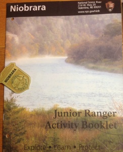
The Niobrara River begins in Wyoming and ends in Missouri, but primarily flows through northern Nebraska. Completing the Junior Ranger booklet gives you an appreciation for the diversity of the river. As the river stretches for 535 miles you can approach the river from many places. Luckily I arrived in Valentine, almost in the middle of the state, and picked up the booklet at the Visitor Center. The ranger was very enthusiastic. She recommended I take the booklet, work on it as I continued to travel east and mail it back when completed.

Inside the front cover it is listed that the booklet “is designed for kids ages 6 – 12, but all ages are welcome”. If you are over 9 you are to complete all of the activity pages. With an upper age listed this program is listed without the Senior Friendly tag, however I appreciated the ranger’s encouragement to complete.

After we left Valentine we visited the Valentine National Wildlife Refuge, which the river flows through. After a short hike along a nature trail and drive through the refuge for some birding we continued east and camped at Smith Falls State Park, also part of the river system. A nice walk from the campground brings you to Smith Falls, tallest waterfall in Nebraska.

The booklet highlights; using your senses, source of the water and it’s variety of uses, a game traveling the river, geology, mammal fossils, animal tracks, fire cycle and a photo bingo. Of the sixteen images on the bingo I was able to observe eleven in the twenty-four hours I spent along the Niobrara National Scenic River.
image

DeSoto National Wildlife Refuge – Iowa

image

DeSoto National Wildlife Refuge
N of. Council Bluffs, IA

http://www.fws.gov/refuge/Desoto

Junior Ranger, Senior-friendly

Completed: September 29, 2013

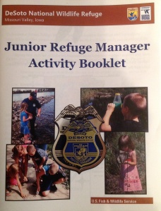
What a fun surprise today! When I arrived at the amazing Visitor Center for DeSoto National Wildlife Refuge (NWR) I learned that they had a Junior Ranger program, or as they call it, Junior Refuge Manager.

This program is well designed for all ages. No age range is given. The number of activities that you complete are based on three time frames; your first visit or you only visit once a year, you visit a couple times a year and if you visit regularly. If I lived in this area not only would I visit regularly, but it would be a great place to volunteer.

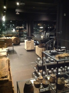
Besides managing and preserving the wildlife this preserve has historical importance. Lewis & Clark camped here in 1804. In 1865 the steamboat Bertrand sunk on part of the river that became part of DeSoto NWR. It was discover and excavated at the end of last century, the mud preserved the cargo. The boat was on it’s way west, to supply the pioneers. The pictures below show some of the incredibly well-preserved cargo.

One of our favorite birds was hanging around on a path near the VC, the Great Blue Heron. It was also confirmed that the squirrels in the area are Fox Squirrels.

While there I received their Junior Ranger award; badge and certificate. Plus the ranger on duty offered an array of other items; pins, bags, coffee cup, etc to choose from, as an additional award. I selected the Blue Goose hatpin.

image